This is a subset of the full dataset, covering the Mediterranean Sea.
The European Space Agency (ESA) commissioned a consortium of experts to develop novel and innovative tools, indicators and methods based on Earth Observation (EO), for the benefit of interested end-users for the monitoring, restoration, and conservation of seagrass meadows, salt marshes and mangroves.
This datasets consists of three file types for the years 2016, 2020, 2024.
HAB-MAP-POLY — predicted Posidonia meadow polygons.
HAB-MAP-GRID — habitat predictions on hexagons with 20 m sides, including bathymetry and confidence.
CARB-MAP — associated predicted carbon stock density on the hexagonal mesh.
Accessing the data
The maps cover 2.2–3.6° E, 39.05–40.0° N, including Mallorca, Cabrera and the surrounding coastal waters.
from pathlib import Path
import geopandas as gpd
import pandas as pd
import matplotlib.pyplot as plt
from matplotlib.colors import BoundaryNorm, ListedColormap
from matplotlib.patches import Patch, Rectangle
import cartopy.crs as ccrs
import cartopy.feature as cfeature
from pyproj import Transformer
from IPython.display import display

BASE_URL = "https://s3.waw4-1.cloudferro.com/EarthCODE/OSCAssets/cbc/med-extract"

URLS = {
    "polygons": f"{BASE_URL}/ESA-CBC_MED_PV0_HAB-MAP-POLY_HS1-lvl1_MULTI_20240301_20241031_S2X_3035.gpkg",
    "grid": f"{BASE_URL}/ESA-CBC_MED_PV0_HAB-MAP-GRID_HS1-lvl1_MULTI_20240301_20241031_S2X_3035.gpkg",
    "carbon": f"{BASE_URL}/ESA-CBC_MED_PV0_CARB-MAP-GRID_CS1-lvl2_SINGL_20241231_X_3035.gpkg",
}

BOUNDS = (2.2, 39.05, 3.6, 40.0)
bbox = Transformer.from_crs(4326, 3035, always_xy=True).transform_bounds(*BOUNDS)
%%time
# its faster to download the whole gpkd and then subset
polygons = gpd.read_file(
    "/vsicurl/" + URLS["polygons"],
    engine="pyogrio",
    use_arrow=True,
)

# limit to Mallorca area
polygons = polygons.cx[bbox[0]:bbox[2], bbox[1]:bbox[3]]

polygons = polygons.replace([-9999, -9998], float("nan")).dropna()
CPU times: user 202 ms, sys: 29.9 ms, total: 232 ms
Wall time: 11 s
%%time

grid = gpd.read_file(
    "/vsicurl/" + URLS["grid"],
    engine="pyogrio",
    use_arrow=True,
)

# limit to Mallorca area
grid = grid.cx[bbox[0]:bbox[2], bbox[1]:bbox[3]]

grid = grid.replace([-9999, -9998], float("nan")).dropna()
CPU times: user 3.12 s, sys: 543 ms, total: 3.66 s
Wall time: 1min 19s
%%time

carbon = gpd.read_file(
    "/vsicurl/" + URLS["carbon"],
    engine="pyogrio",
    use_arrow=True,
)

carbon = carbon.cx[bbox[0]:bbox[2], bbox[1]:bbox[3]]

carbon = carbon.replace([-9999, -9998], float("nan")).dropna()
CPU times: user 2.82 s, sys: 457 ms, total: 3.28 s
Wall time: 1min 13s
HAB-MAP-POLY
Habitat Map (polygon) - Mediterranean Pilot Region Version 0 (2024-03-01 - 2024-10-31)
This dataset is a predictive map of our habitats of interest (salt marsh, seagrass, mangrove) represented with polygons, in Geopackage format. Two levels of typology can be proposed: class-lv1,which corresponds to the presence of a habitat, and class-lvl2, which corresponds to a finer discrimination of our habitats into broad classes (e.g.: Seagrass densities and Salt marsh belts). The polygons are the results of a pixel-level prediction based on Sentinel 2 time series analysis through machine learning.
In this Mediterranean extract, the predicted habitat is Posidonia, code 7, shown in green. The polygons describe predicted meadow boundaries.
| Metadata | Value |
|---|---|
| Metadata identifier | 9709c601-c0d4-446a-9d3d-c09d2563a939 |
| Metadata date | 2026-02-06 |
| Publication date | 2026-02-06 |
| Metadata language / encoding | French (fre) / UTF-8 (utf8) |
| Coordinate reference system | EPSG:3035 — ETRS89-extended / LAEA Europe |
| Observation period | 2024-03-01 to 2024-10-31 |
| Spatial resolution recorded in XML | 10 m |
| Geographic bounds (longitude) | -7.229857956347076 to 10.314641151947304° |
| Geographic bounds (latitude) | 37.30273144839746 to 42.34809245162647° |
| Distribution format | Geopackage, version 1.0 |
| Topic category | environment |
| Metadata XML schema | http:// |
Contacts
Metadata contact: Cecile Curti, i-Sea — cecile
.curti@i -sea .fr. Resource provider: Benoit Beguet, i-Sea — benoit
.beguet@i -sea .fr. Resource provider: Oscar Serrano, CEAB — oserrano@ceab.csic.es.
Keywords
Place: Mediterranean, Pilot Region Version 0.
Theme: Habitats and biotopes, Bio-geographical regions. Thesaurus: GEMET - INSPIRE themes, version 1.0; published 2008-06-01. Identifier:
geonetwork.thesaurus.external.theme.httpinspireeceuropaeutheme-theme. Registry address recorded in XML:http://localhost:8080/geonetwork/srv/api/registries/vocabularies/external.theme.httpinspireeceuropaeutheme-theme.Theme: Coastal Blue Carbon, ESA, European Space Agency, i-Sea, CEAB, Habitat mapping, Satellite, EO, Earth Observation, Copernicus, Monitoring, Mediterranean Coast, Subtidal Seagrass, Posidonia.
Lineage and processing
The habitat map is produced with a machine learning process (RandomForest) using labelled reference data at the hexagonal mesh scale and Sentinel 2 time series (selected at low tide during the growing season between March and October). A specific typology was defined to exhaustively describe land cover. Reference samples were then constructed on the basis of VHR images, field observations or existing maps. Sentinel 2 images were selected and prepared, and a set of radiometric indices were then calculated and added to the information stack. A RandomForest classification model was then trained and evaluated before being applied to all image pixels. The raw prediction was vectorized, and the classes of interest were selected. Depending on the typology level of the reference data, the model is trained and applied with level2 typology the predicted classes are merged to obtain level1 typology. If level2 is not available, the model is trained and applied with level1 typology. This product has also been trained and predicted at local site level, with no validation step.
Funding, rights and attribution
This project has received funding from the European Space Agency’s Earth Observation Science for Society (EO4Society) programmatic element of the ESA FutureEO-1 Segment-2 Programme, Coastal Blue Carbon project under Contract No. 4000143758/23/I-NS (c) 2024-2026, CBC Product, i-Sea, All rights reserved contains ESA Copernicus data 2024
HAB-MAP-GRID
Habitat Map Hexagonal (hexagonal mesh) - Mediterranean Pilot Region Version 0 (2024-03-01 - 2024-10-31)
This layer is a predictive map of habitats of interest (salt marsh, seagrass, mangrove) represented on a fixed hexagonal grid of 20m sides, in Geopackage format. Two levels of typology are proposed: class-lv1, which corresponds to the presence of the above-mentioned habitats, and class-lvl2, which corresponds to a finer discrimination (e.g.: seagrass densities and salt marsh vegetation communities). The hexagonal mesh is the result of a majority voting system from the pixel-level predicted and vectorized map based on Sentinel 2 time series analysis through a machine learning, proposed in the product: ‘Habitat map polygon’.
The grid also contains bathymetry (mean_bathy), classification margins (margin_mean, margin_std), and confidence (confidence_score, confidence_legend). The five confidence classes are very high, high, moderate, low and very low. Confidence is a model indicator, rather than a measured accuracy rate. The bathymetry unit and vertical datum are unspecified. The 20 m hexagon side length describes the mesh; the XML resolution field below records 10 m.
| Metadata | Value |
|---|---|
| Metadata identifier | 51e51758-f549-4f6a-a5db-ff47b537dc28 |
| Metadata date | 2026-02-06 |
| Publication date | 2026-02-06 |
| Metadata language / encoding | French (fre) / UTF-8 (utf8) |
| Coordinate reference system | EPSG:3035 — ETRS89-extended / LAEA Europe |
| Observation period | 2024-03-01 to 2024-10-31 |
| Spatial resolution recorded in XML | 10 m |
| Geographic bounds (longitude) | -7.227540379009844 to 10.315043579880012° |
| Geographic bounds (latitude) | 37.30242537840972 to 42.34881482953961° |
| Distribution format | Geopackage, version 1.0 |
| Topic category | environment |
| Metadata XML schema | http:// |
Contacts
Metadata contact: Cecile Curti, i-Sea — cecile
.curti@i -sea .fr. Resource provider: Benoit Beguet, i-Sea — benoit
.beguet@i -sea .fr. Resource provider: Oscar Serrano, CEAB — oserrano@ceab.csic.es.
Keywords
Place: Mediterranean, Pilot Region Version 0.
Theme: Habitats and biotopes, Bio-geographical regions. Thesaurus: GEMET - INSPIRE themes, version 1.0; published 2008-06-01. Identifier:
geonetwork.thesaurus.external.theme.httpinspireeceuropaeutheme-theme. Registry address recorded in XML:http://localhost:8080/geonetwork/srv/api/registries/vocabularies/external.theme.httpinspireeceuropaeutheme-theme.Theme: Coastal Blue Carbon, ESA, European Space Agency, i-Sea, CEAB, Habitat mapping, Satellite, EO, Earth Observation, Copernicus, Monitoring, Hexagonal mesh, Mediterranean Coast, Subtidal Seagrass, Posidonia.
Lineage and processing
The habitat map is produced with a machine learning process (RandomForest) using labelled reference data at the hexagonal mesh scale and Sentinel 2 time series (selected at low tide during the growing season between March and October). A specific typology was defined to exhaustively describe land cover. Reference samples were then constructed on the basis of VHR images, field observations or existing maps. Sentinel 2 images were selected and prepared, and a set of radiometric indices were then calculated and added to the information stack. A RandomForest classification model was then trained and evaluated before being applied to all image pixels. The raw prediction was vectorized, and the classes of interest were selected. Depending on the typology level of the reference data, the model is trained and applied with level2 typology the predicted classes are merged to obtain level1 typology. If level2 is not available, the model is trained and applied with level1 typology. The prediction is then adapted to the hexagonal mesh by assigning each hexagon the value of the class that covers the majority of its area. This product has also been trained and predicted at local site level, with no validation step.
Funding, rights and attribution
This project has received funding from the European Space Agency’s Earth Observation Science for Society (EO4Society) programmatic element of the ESA FutureEO-1 Segment-2 Programme, Coastal Blue Carbon project under Contract No. 4000143758/23/I-NS (c) 2024-2026, CBC Product, i-Sea, All rights reserved contains ESA Copernicus data 2024
CARB-MAP
Carbon Stock Map (hexagonal mesh) - Mediterranean Pilot Region Version 0 (2024-12-31)
This product is a predictive map of carbon stocks present in our ecosystems of interest (salt marsh, seagrass, mangrove). Carbon values
mean_carbon_stocks is carbon stock density in Mg/ha, with display intervals 0–50, 50–100, 100–150, 150–200, 200–250, 250–300, 300–350 and 350–500. Densities cannot be summed directly into total carbon mass. The unit and time basis of mean_carbon_accum are unspecified in the metadata.
| Metadata | Value |
|---|---|
| Metadata identifier | 8a740c6d-bb4b-46b9-936e-10d602cf111d |
| Metadata date | 2026-02-06 |
| Publication date | 2026-02-06 |
| Metadata language / encoding | French (fre) / UTF-8 (utf8) |
| Coordinate reference system | EPSG:3035 — ETRS89-extended / LAEA Europe |
| Observation period | 2024-12-31 to 2024-12-31 |
| Spatial resolution recorded in XML | 0 m (placeholder; the abstract describes a hexagonal mesh) |
| Geographic bounds (longitude) | -7.227540379009844 to 10.315043579880012° |
| Geographic bounds (latitude) | 37.30242537840972 to 42.34881482953961° |
| Distribution format | Geopackage, version 1.0 |
| Topic category | environment |
| Metadata XML schema | http:// |
Contacts
Metadata contact: Cecile Curti, i-Sea — cecile
.curti@i -sea .fr. Resource provider: Benoit Beguet, i-Sea — benoit
.beguet@i -sea .fr. Resource provider: Oscar Serrano, CEAB — oserrano@ceab.csic.es.
Keywords
Place: Mediterranean, Pilot Region Version 0.
Theme: Habitats and biotopes, Bio-geographical regions. Thesaurus: GEMET - INSPIRE themes, version 1.0; published 2008-06-01. Identifier:
geonetwork.thesaurus.external.theme.httpinspireeceuropaeutheme-theme. Registry address recorded in XML:http://localhost:8080/geonetwork/srv/api/registries/vocabularies/external.theme.httpinspireeceuropaeutheme-theme.Theme: Coastal Blue Carbon, ESA, European Space Agency, i-Sea, CEAB, Habitat mapping, Satellite, EO, Earth Observation, Copernicus, Sentinel-2, Monitoring, Hexagonal mesh, Mediterranean Coast, Subtidal Seagrass, Posidonia, Carbon map.
Lineage and processing
The carbon maps are derived from the habitat maps produced for the project.Carbon values were estimated using BRT modeling of environmental variables and applied to predicted habitat contours in hexagonal grid format. Carbon maps for three different years were produced (2016, 2020, and 2024)
Funding, rights and attribution
This project has received funding from the European Space Agency’s Earth Observation Science for Society (EO4Society) programmatic element of the ESA FutureEO-1 Segment-2 Programme, Coastal Blue Carbon project under Contract No. 4000143758/23/I-NS (c) 2024-2026, CBC Product, i-Sea, All rights reserved products derived from external data 2024
# set styling data
habitat_color = "#29ac32"
confidence_colors = {
    "Very high confidence": "#faebdd",
    "High confidence": "#f58860",
    "Moderate confidence": "#cb1b4f",
    "Low confidence": "#611f53",
    "Very low confidence": "#03051a",
}
carbon_bins = [0, 50, 100, 150, 200, 250, 300, 350, 500]
carbon_cmap = ListedColormap(["#f0f9e8", "#d1edcf", "#b1e1bd", "#8dd3c2",
                              "#6bc0c6", "#4ba8c9", "#2a89bd", "#0868ac"])
carbon_cmap.set_under("#bdbdbd")
carbon_cmap.set_over("#bdbdbd")
carbon_norm = BoundaryNorm(carbon_bins, carbon_cmap.N)
# convert to lon,lat for cartopy
carbon = carbon.to_crs(epsg=4326)
polygons = polygons.to_crs(epsg=4326)
grid = grid.to_crs(epsg=4326)
projection = ccrs.PlateCarree()
fig, axes = plt.subplots(2, 2, figsize=(15, 12), subplot_kw={"projection": projection})
for ax in axes.flat:
    ax.set_facecolor("#eaf2f5")
    ax.add_feature(cfeature.LAND.with_scale("10m"), facecolor="#eee9dc")
    ax.coastlines(resolution="10m", linewidth=0.6)
    labels = ax.gridlines(draw_labels=True, linewidth=0.3, alpha=0.4)
    labels.top_labels = labels.right_labels = False

locator, habitat, confidence, stocks = axes.flat
locator.set_extent([0.0, 5.0, 38.0, 41.5], crs=projection)
locator.add_patch(Rectangle((BOUNDS[0], BOUNDS[1]), BOUNDS[2]-BOUNDS[0], BOUNDS[3]-BOUNDS[1],
                            fill=False, edgecolor="#c72535", linewidth=2, transform=projection))
locator.text(2.6, 39.65, "Mallorca", transform=projection, fontsize=10)
locator.text(1.1, 39.1, "Ibiza", transform=projection, fontsize=10)
locator.text(3.7, 40.15, "Menorca", transform=projection, fontsize=10)
locator.set_title("Balearic Islands · 2024")
for ax in (habitat, confidence, stocks):
    ax.set_extent([BOUNDS[0], BOUNDS[2], BOUNDS[1], BOUNDS[3]], crs=projection)

habitat.add_geometries(polygons.geometry, projection, facecolor=habitat_color,
                       edgecolor="white", linewidth=0.05)
habitat.set_title("HAB-MAP-POLY · Posidonia meadows")
habitat.legend(handles=[Patch(color=habitat_color, label="Posidonia")], loc="upper left")
confidence.add_geometries(grid.geometry, projection,
                          facecolor=grid.confidence_legend.map(confidence_colors).fillna("#bdbdbd").tolist(),
                          edgecolor="none")
confidence.set_title("HAB-MAP-GRID · Confidence")
confidence.legend(handles=[Patch(color=color, label=label) for label, color in confidence_colors.items()],
                  loc="upper left", fontsize=8)
stocks.add_geometries(carbon.geometry, projection,
                       facecolor=carbon_cmap(carbon_norm(carbon.mean_carbon_stocks)), edgecolor="none")
stocks.set_title("CARB-MAP · Carbon stock density")
fig.colorbar(plt.cm.ScalarMappable(norm=carbon_norm, cmap=carbon_cmap), ax=stocks,
             orientation="horizontal", pad=0.1, shrink=0.85, label="Carbon stock (Mg/ha)")
plt.tight_layout()
plt.show()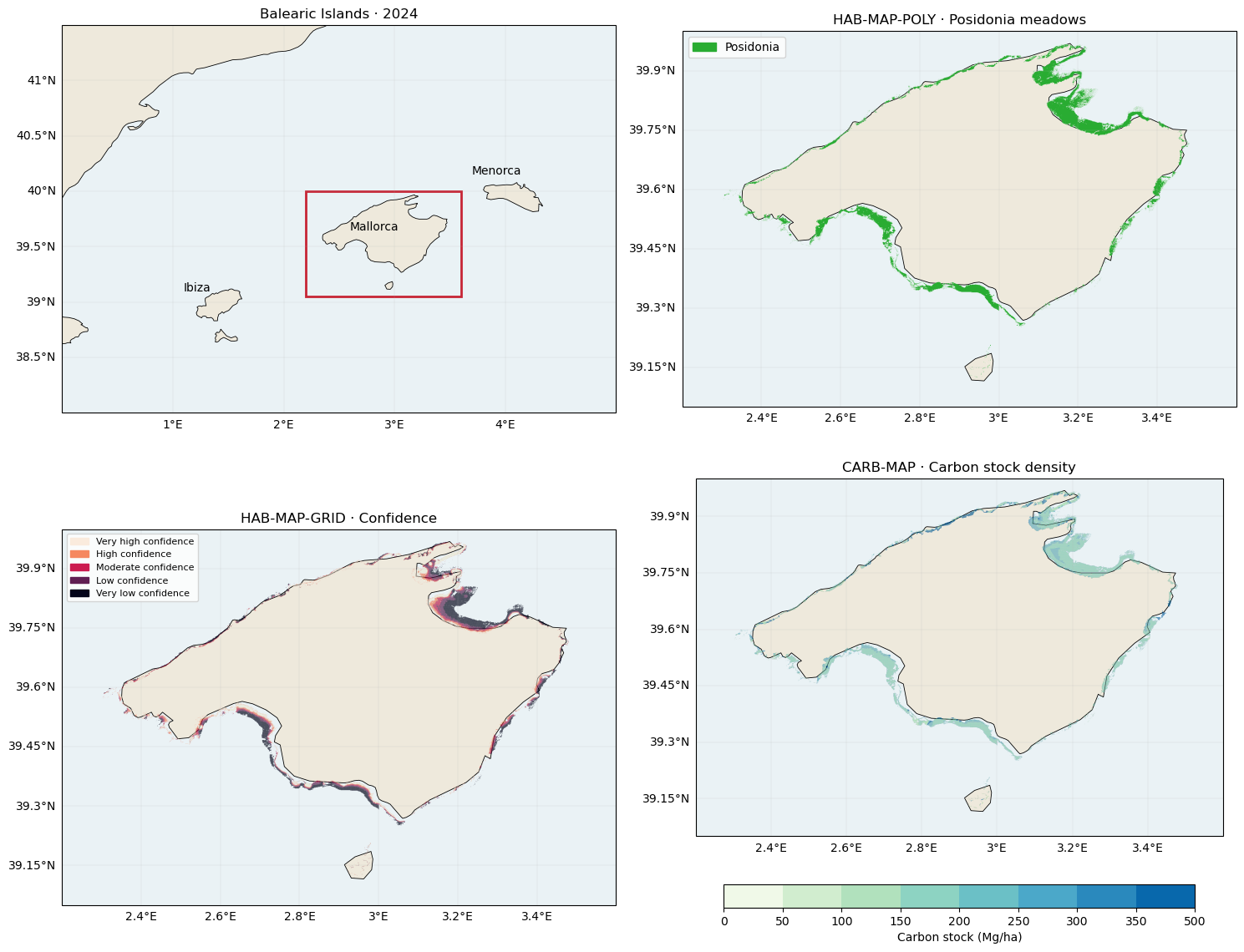
display(pd.DataFrame({
    "Bathymetry (stored values)": grid.mean_bathy.describe(),
    "Confidence score": grid.confidence_score.describe(),
    "Carbon stock (Mg/ha)": carbon.mean_carbon_stocks.describe(),
}).round(2))